Abstract
The Comoé Estuary, located in Grand-Bassam, Côte d'Ivoire, is a coastal ecosystem of major ecological and socio-economic importance. Since the permanent opening of its mouth in September 2023, the estuary has experienced hydrological and environmental disturbances whose magnitude remains poorly documented. This study adopts an integrated approach combining morphobathymetric characterization and the analysis of the spatial distribution of water physicochemical parameters. A sonar survey conducted on January 3, 2026, yielded 44,097 bathymetric sounding points. Five physicochemical parameters were measured in situ at 95 stations on February 28, 2026. Results reveal a heterogeneous estuarine bed, with depths ranging from 0 to 17 m (mean: 4 m), and two types of morphological profiles. V-shaped profiles indicate dominant erosion, whereas intermediate profiles reflect an unstable balance between erosion and sedimentation. These findings point to a mixed and unstable depositional environment characterized by continental inputs and marginal marine conditions. From a physicochemical perspective, pH values (7.13-8.38) indicate a generally alkaline environment. Conductivity (17.43-55.20 µS/cm) and salinity (0.968-3.59‰) reflect a strong marine influence downstream, while dissolved oxygen concentrations (0.10-0.30 mg/L) reveal a state of severe hypoxia, representing the most critical ecological constraint of the system. Pearson correlation analysis confirms a very strong relationship between conductivity and salinity (r = 0.998), as well as strong negative correlations between temperature and mineralization-related parameters. These correlations indicate that water has become a vector of persistent pollution that weakens the ecosystem and threatens the food security and health of local populations. The environment is progressively losing its capacity for regeneration, and the impacts may be transmitted across generations.
|
Published in
|
Journal of Water Resources and Ocean Science (Volume 15, Issue 4)
|
|
DOI
|
10.11648/j.wros.20261504.12
|
|
Page(s)
|
165-176 |
|
Creative Commons
|

This is an Open Access article, distributed under the terms of the Creative Commons Attribution 4.0 International License (http://creativecommons.org/licenses/by/4.0/), which permits unrestricted use, distribution and reproduction in any medium or format, provided the original work is properly cited.
|
|
Copyright
|
Copyright © The Author(s), 2026. Published by Science Publishing Group
|
Keywords
Estuary, Comoé, Bathymetry, Morphology, Physicochemical Parameters, Grand-Bassam, Côte d'Ivoire
1. Introduction
Estuaries are transitional zones between continental and marine environments, where intense physicochemical and hydrodynamic processes govern both morphology and ecological functioning
| [1] | Dyer, K. R. (1997). Estuaries: A Physical Introduction (2nd ed.). John Wiley & Sons Ltd., Chichester, United Kingdom, 195 p. |
[1]
. According to Pritchard
| [2] | Pritchard, D. W. (1967). What is an estuary: A physical viewpoint. In G. H. Lauff (Ed.), Estuaries. American Association for the Advancement of Science, Washington, D. C. 149-176 |
[2]
, an estuary is a semi-enclosed body of water that has a free connection with the open sea and within which seawater is measurably diluted by freshwater inflows from land. These environments constitute natural areas of considerable economic value, particularly for artisanal fisheries, tourism, and sand extraction. However, their ecological balance is increasingly threatened by climate change and growing anthropogenic pressures.
The Comoé River estuary at Grand-Bassam, located at the eastern end of the Ebrié Lagoon, is one of the most complex estuarine systems along the Ivorian coast. Following the opening of the Vridi Canal in 1951, a water deficit developed at its natural mouth, considerably reducing river discharge in favor of longshore drift and channel siltation
| [3] | Adopo, K. L., Kouassi, K. L., Wognin, A. V. I., Monde, S., & Aka, K. (2008). Sediment Characteristics and Morphology of the Comoé River Mouth (Grand-Bassam, Côte d'Ivoire). Paralia, 1(1), 2.1-2.10.
https://orcid.org/10.5150/2008.002 |
[3]
. However, the permanent opening of the estuary mouth in September 2023 reactivated hydrodynamic exchanges between the estuary and the ocean, potentially leading to significant changes in hydrosedimentary dynamics and physicochemical conditions.
Several studies have documented the hydrological and sedimentological characteristics of this estuary. However, these investigations were conducted before 2023 and therefore no longer reflect the current state of the system. Furthermore, no study has yet proposed an integrated approach simultaneously combining high-resolution morphobathymetric characterization and spatial analysis of physicochemical parameters within this post-opening context.
Within this framework, the present study aims to characterize the morphobathymetric and physicochemical aspects of the Comoé Estuary at Grand-Bassam and to determine their hydrosedimentary and environmental implications.
2. Materials and Methodes
2.1. Presentation of Study Area
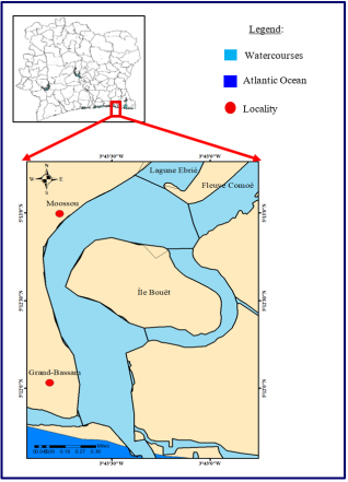
The Comoé Estuary is located in Grand-Bassam, southeastern Côte d'Ivoire, at the eastern extremity of the Ebrié Lagoon (
Figure 1). It receives inflows from the Comoé River, which is 1,160 km long and drains a watershed of approximately 78,000 km
2 distributed among Côte d'Ivoire (74.7%), Burkina Faso (21.6%), Ghana (2.7%), and Mali (1%)
| [4] | UNESCO. (2019). Assessment of Flood Impacts on the Heritage of the Historic City of Grand-Bassam. UNESCO Office, Abidjan, Côte d'Ivoire, 87 p. |
[4]
. Geographically, the estuary is situated between 5°12′ and 5°14′ North latitude and 3°43′ and 3°44′ West longitude.
Figure 1. Geographic location of the Comoé River Estuary.
2.2. Field Equipment
2.2.1. Bathymetric Data Acquisition Equipement
The equipment used during the bathymetric survey consisted of:
1) A motorized boat for navigating across the water body.
2) A Garmin GPS (Global Positioning System) used to determine the location of measurement stations. It continuously provides accurate positioning and navigation data.
3) A LOWRANCE Elite FS7 echo sounder powered by a battery. This device records data in digital format. It includes a transducer, which emits acoustic signals by converting electrical energy into sound energy, and a central processing unit that receives and converts the signals into digital data.
2.2.2. Physicochemical Data Acquisition Equipment
During the field campaign carried out in the study area, water samples were collected using a plastic sampling container (a cut water bottle) used as a sample collection device. The physicochemical parameters of the water were measured in situ using a PCE-PHD 1 multiparameter probe, which allows the simultaneous determination of several parameters, including temperature (T°), pH, electrical conductivity, dissolved oxygen, and salinity.
2.3. Methods
2.3.1. Bathymetric Data
(i). Bathymetric Survey
Bathymetric surveys were conducted on January 3, 2026, to characterize the morphology of the Comoé Estuary bed at Grand-Bassam. A bathymetric survey allows for the accurate determination of water depth and its representation in the form of a map including isobaths, regardless of the nature of the site under investigation. Measurements were carried out according to the bathymetric survey standardization guide
| [5] | Ministry of Natural Resources and Wildlife (MRNF). (2011). Guidelines for the Standardization of Bathymetric Surveys (Wildlife Sector). Quebec, Canada, 41 p. |
[5]
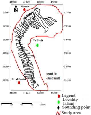
. These standards define the spacing between survey transects and the sampling interval according to the surface area of the aquatic environment. In total, approximately 44,000 georeferenced sounding points (X, Y, Z) were recorded throughout the Comoé Estuary (
Figure 1), providing the database required for the production of morphobathymetric maps using SURFER 11.5.1069 mapping software developed by Golden Software Inc.
Table 1. Bathymetric Survey Standardization Guide.
Water Body Area (ha) | Distance Between Transects (m) | Distance Between Soundings (m) |
< 50 | 25 | 10 |
50 to 200 | 50 | 10 |
200 to 1000 | 100 | 10 |
> 1000 | 150 | 20 |
Figure 2. Distribution Map of Bathymetric Sounding Points in the Comoé River Estuary.
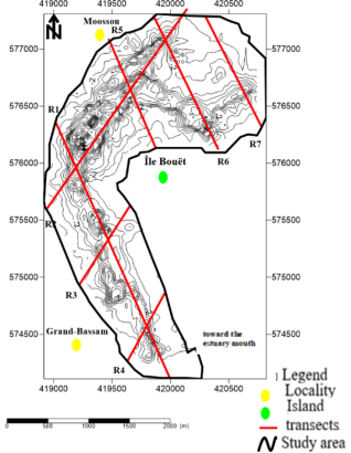
Figure 3. Location Map of Bathymetric Transects.
(ii). Channel Configuration
Characterizing the channels makes it possible to monitor morphological changes in the bed of the Comoé Estuary. To this end, seven transects were drawn on the bathymetric map to identify the main types of morphological profiles present in the study area (
Figure 3). These transects, oriented along SW-NE and NW-SE directions, cover the entire estuarine system, extending from the northern area toward Moossou to the estuary mouth toward Grand-Bassam, including both banks of Bouët Island. The profiles extracted along these transects were used to identify the principal bottom forms characteristic of the estuary.
2.3.2. Physicochemical Data
(i). Sampling Methods
Sampling consisted of collecting representative portions of water in order to characterize its physicochemical properties. For this study, the sampling campaign was conducted on February 28, 2026. Samples were collected aboard a motorized boat used to travel across the water body. Sampling was carried out at the surface, at an approximate depth of 0.5 m, in order to characterize the physicochemical conditions of the surface water layer.
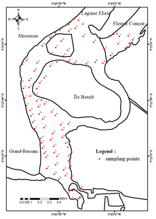
Figure 4. Location of Physicochemical Sampling Stations.
A total of 95 stations were sampled throughout the study area (
Figure 4). Among these, stations 4 to 12 were located within the Comoé River in order to account for the influence of river inputs on estuarine water quality. Physicochemical parameters were measured
in situ. The probes were immersed directly in the water sample collected in the container. Measurements were taken once the values displayed on the instrument screen had stabilized, thereby ensuring data reliability and minimizing any alteration of water properties.
The use of in situ measurements helps prevent physicochemical modifications that may occur during sample transport and storage, thus ensuring a more accurate representation of actual environmental conditions. Bathymetric maps were generated using SURFER 11.5.1069 mapping software developed by Golden Software Inc.
(ii). Processing of Physicochemical Data
All data collected during the field survey were recorded on field sheets for subsequent processing and analysis. Using ArcGIS software, spatial distribution maps were produced for each physicochemical parameter. The preparation of these maps involved two major steps.
The first step consisted of entering into an Excel spreadsheet the numerical values of the physicochemical parameters previously measured, together with the coordinates of the sampling locations. These coordinates were then combined with the boundary of the study area obtained from Google Earth.
The second step involved the actual creation of spatial distribution maps for each physicochemical parameter based on the sampling points. Using ArcGIS, interpolation was performed through the Inverse Distance Weighted (IDW) method. This interpolation technique estimates the value of a location by calculating a weighted average of neighboring known points
| [6] | Meledje, N. H., Kouassi, K. L., N'Go, Y. A., Kouassi, K. M., Savane, I., & Aka, K. (2014). Characterization of Sediment Inputs and Morphology of the Ayamé 1 Hydroelectric Reservoir (Southeastern Côte d'Ivoire). International Journal of Biological and Chemical Sciences, 8(3), 1290-1307.
https://orcid.org/10.4314/ijbcs.v8i3.42 |
[6]
. The closer a known point is to the location being estimated, the greater its influence on the averaging process.
3. Results
3.1. Morphobathymetry of the Estuary
3.1.1. 2D Bathymetric Map and Digital Terrain Model (DTM)
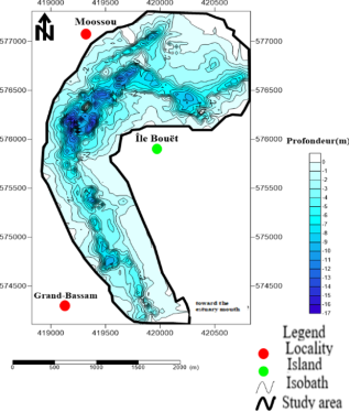
The 2D bathymetric map of the Comoé Estuary reveals depths ranging from 0 to 17 m, with an average depth of 4 m (
Figure 5). Maximum depths are concentrated within the main channel located in the central part of the estuary, where a pronounced depression reaches 17 m. The bottom is generally heterogeneous, characterized by a succession of channels and shallow depositional zones.
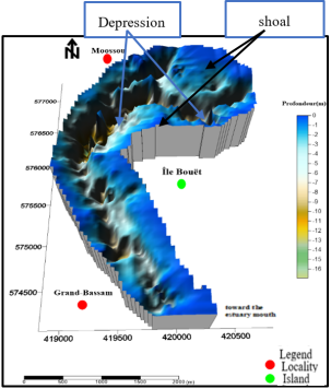
The Digital Terrain Model (DTM) confirms this heterogeneity. The three-dimensional representation highlights the alternation of deep depressions associated with erosive currents and dredging activities, and sedimentary shoals corresponding to low-energy hydrodynamic environments favorable to material accumulation (
Figure 6).
Figure 5. 2D Bathymetric Map of the Comoé River Estuary.
Figure 6. Digital Terrain Model (DTM) of the Comoé River Estuary.
3.1.2. Water Circulation and Slope Evolution
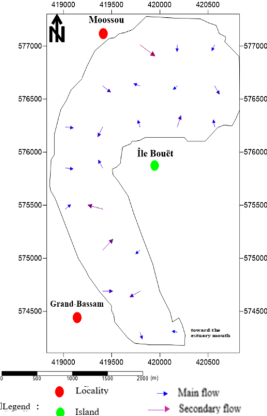
Figure 7. Water Flow Circulation Map of the Comoé River Estuary.
`
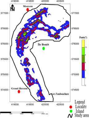
Figure 8. Slope Map of the Comoé River Estuary.
Flow vectors derived from the bathymetric map are mainly oriented along the North-South and East-West directions, converging toward the deepest areas of the estuary (
Figure 7). Slope analysis, based on the Canadian classification system (GTCS, 2002), identified five slope classes: sub-horizontal slopes (0-2°), which are by far the most dominant, very gentle slopes (2-4°), gentle slopes (4-6°), moderate slopes (6-8°), and steep slopes (8-10°). The latter are strictly confined to the flanks of the main channel, where dredging-related erosional processes are most active (
Figure 8).
3.1.3. Interpretation of Morphological Profiles
Processing of the bathymetric data collected from the Comoé Estuary made it possible to identify two types of morphological profile s« V » shaped profiles and intermediate profiles.
(i). V-Shaped Profile
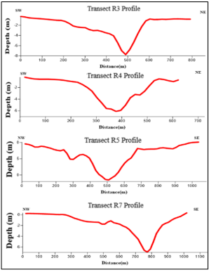
The profiles corresponding to transects R3, R4, R5, and R7 (
Figure 9) exhibit a V-shape, with inclined sides descending toward a narrow and deep bottom. This morphology indicates that erosion is the dominant process in these areas. Water currents are sufficiently strong to remove sediments and deepen the channel further. This process is also reinforced by dredging activities carried out within these sectors of the estuary.
Figure 9. V- Shaped Bathymetric Profile.
(ii). Intermediate Profile
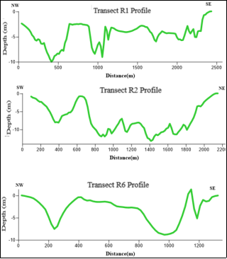
The profiles corresponding to transects R1, R2, and R6 (
Figure 10) are classified as intermediate profiles, characterized by a succession of depressions and elevations. They do not correspond either to a V-shaped or a U-shaped morphology. They reflect conditions in which erosional and depositional forces compete without either process becoming dominant. This type of profile represents a transitional stage in bottom evolution, between a strongly eroded V-shaped form and a more stable U-shaped morphology.
Figure 10. i. ntermediaite Bathymetric Profile.
3.2. Spatial Variability of Physicochemical Parameters
Descriptive statistics for the five parameters measured at the 95 sampling stations are presented in
Table 2.
The pH and temperature values remain stable across all sampling stations, showing low variability. Conductivity, salinity, and dissolved oxygen exhibit moderate variability, suggesting spatial and/or temporal heterogeneity likely related to river inflows, tidal influence, or freshwater-seawater mixing within the estuary. Although dissolved oxygen displays a moderate coefficient of variation (27.78%), its absolute values remain extremely low (0.10-0.30 mg/L), indicating conditions close to hypoxia.
Table 2. Descriptive Statistics of Physicochemical Parameters in the Waters of the Comoé Estuary.
Parameter | Minimum | Maximum | Mean | Standard Deviation | Coefficient of Variation (%) |
pH | 7.13 | 8.38 | 8.17 | 0.32 | 3.92 |
Conductivity (µS/cm) | 17.43 | 55.20 | 49.44 | 10.84 | 21.93 |
Temperature (°C) | 28.20 | 30.20 | 28.63 | 0.53 | 1.85 |
Salinity (‰) | 0.968 | 3.59 | 3.15 | 0.75 | 23.81 |
Dissolved O2 (mg/L) | 0.10 | 0.30 | 0.18 | 0.05 | 27.78 |
3.2.1. pH
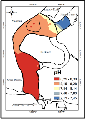
The pH ranges from 7.13 to 8.38, with an average value of 8.17, indicating generally alkaline waters. The highest values (8.15-8.38) dominate the downstream portion of the estuary under marine influence, whereas the lowest values (7.13-7.45) occur in the riverine section (northeastern area), where organic matter decomposition processes enrich the waters with CO
2 (
Figure 11).
Figure 11. Spatial Distribution of pH in the Comoé Estuary.
3.2.2. Electrical Conductivity and Salinity
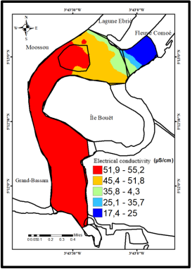
Conductivity ranges from 17.43 to 55.20 µS/cm (mean: 49.44 µS/cm) (
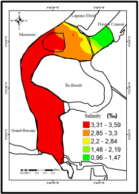
Figure 12), while salinity varies between 0.968 and 3.59‰ (mean: 3.15‰)(
Figure 13). Both parameters display nearly identical spatial distributions: maximum values occur in the southern sector toward the estuary mouth, reflecting a strong marine influence, whereas minimum values are observed in the northeastern riverine zone. A decreasing south-to-north gradient reflects the progressive mixing of mineralized marine waters with freshwater inflows.
Figure 12. Spatial Distribution of Electrical Conductivity in the Comoé Estuary.
Figure 13. Spatial Distribution of Salinity in the Comoé Estuary.
3.2.3. Temperature
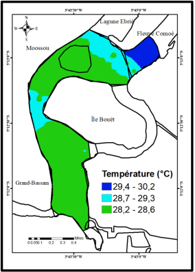
Figure 14. Spatial Distribution of Water Temperature in the Comoé Estuary.
Temperature ranges from 28.2 to 30.2 °C, with a mean value of 28.63 °C, confirming the stable thermal conditions characteristic of tropical environments. The highest temperatures (29.4-30.2 °C) were recorded in the riverine sector, which is shallower and more exposed to solar radiation, whereas cooler temperatures prevail in the estuarine zone, where marine waters exert a thermal buffering effect (
Figure 14),
3.2.4. Dissolved Oxygen
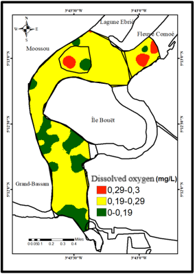
Dissolved oxygen concentrations range from 0.10 to 0.30 mg/L (mean: 0.18 mg/L), values well below the critical threshold of 2 mg/L generally required for the survival of most aquatic organisms. This severe hypoxic condition is observed throughout the estuary, with the lowest concentrations (0-0.19 mg/L) located in the central and southern sectors (
Figure 15).
Figure 15. Spatial Distribution of Dissolved Oxygen in the Comoé Estuary.
3.3. Pearson Correlation Analysis
The correlation matrix (
Table 3) reveals a very strong positive correlation between conductivity and salinity (r = 0.998), confirming their common origin in marine mineralization processes. Significant positive correlations were also observed between pH and conductivity (r = 0.959), as well as between pH and salinity (r = 0.956). Temperature showed strong negative correlations with conductivity (r = -0.930) and salinity (r = -0.929). Dissolved oxygen exhibited no significant correlation with any of the other parameters (|r| < 0.28).
Table 3. Pearson Correlation Matrix of Physicochemical Parameters in the Waters of the Comoé Estuary.
Parameters | pH | Conductivity | Temperature | Salinity | O2 |
pH | 1 | - | - | - | - |
Conductivity (µS/cm) | 0.959 | 1 | - | - | - |
Temperature (°C) | -0.937 | -0.930 | 1 | - | - |
Salinity (‰) | 0.956 | 0.998 | -0.929 | 1 | - |
Dissolved O2 (mg/L) | -0.212 | -0.238 | 0.223 | -0.243 | 1 |
Key Interpretation of the Correlation Analysis
The extremely strong relationship between conductivity and salinity confirms that seawater intrusion is the main driver of mineralization in the estuary. The strong positive correlations between pH, conductivity, and salinity indicate that alkaline conditions increase downstream under marine influence. Conversely, higher temperatures are associated with less mineralized waters located in the upstream riverine zone. The absence of significant correlations involving dissolved oxygen suggests that oxygen dynamics are controlled by additional factors such as biological respiration, photosynthesis, organic matter decomposition, and anthropogenic inputs rather than by marine-freshwater mixing processes alone.
4. Discussion
4.1. Morphobathymetric Dynamics and Hydrosedimentary Evolution
The morphobathymetric configuration of the Comoé Estuary reveals an active and evolving hydrosedimentary system. Maximum depths reaching 17 m exceed by approximately 3 m those reported by
| [10] | N'Guessan, Y. A., Wango, T. E., Konan, K. E., Adingra, A., Amani, E. M., Monde, S., & Aka, K. (2015). Hydrology and Morphology of the Sassandra River Estuary, Lower Côte d'Ivoire. |
[10]
, who recorded a maximum depth of 14 m in the same estuary. This increase suggests a significant intensification of erosional processes during the last two decades. The observed deepening is likely related to both continuous dredging activities and the permanent opening of the estuary mouth in September 2023, which enhanced ocean-estuary exchanges and modified current patterns within the system.
The coexistence of V-shaped and intermediate profiles reflects contrasting hydrosedimentary dynamics. V-shaped profiles, observed within the main channels, indicate dominant erosional processes associated with concentrated water flows and dredging activities
| [7] | Kouamé, A. F. (2017). Contribution of Morphobathymetry to the Characterization of Sediment Dynamics in Fluvio-Lagoonal Environments of Côte d'Ivoire. PhD Thesis, Félix Houphouët-Boigny University, Abidjan, Côte d'Ivoire, 239 p |
[7]
. Intermediate profiles, identified along the peripheral zones of the estuary, correspond to sectors in unstable equilibrium where reduced hydrodynamic energy favors the onset of sediment accumulation without allowing long-term stabilization
| [8] | Konan, G. S. (2023). Integrated Water Resources Management in Côte d'Ivoire: Environmental Quality and Modeling of Sediment Dynamics in the Buyo Hydroelectric Reservoir. PhD Thesis, University of Cocody, Abidjan, Côte d'Ivoire, 218 p |
[8]
The predominance of sub-horizontal slopes over most of the estuarine bed, contrasted with the steep slopes along the main channel, further reflects this spatial alternation between active erosion zones and depositional environments.
4.2. Environmental Variability and Ecological Implications
The pH values measured in the Comoé Estuary (7.13-8.38; mean: 8.17) are comparable to those reported by El Morhit et al.
| [9] | El Morhit, M., Fekhaoui, M., Serghini, A., El Blidi, S., El Abidi, U., Yahyaoui, U., & Hachimi, M. (2012). Spatio-Temporal Assessment of Hydrological Parameters Characterizing Water Quality in the Loukkos Estuary (Morocco). Bulletin de l'Institut Scientifique, 34(2), 151-162. https://www.scirp.org/ 3043310 |
[9]
in the Loukkos Estuary (Morocco), where an increasing pH gradient from upstream areas toward the estuary mouth reflected the growing influence of alkaline marine waters. This spatial pattern, also observed in the Comoé Estuary, constitutes a reliable indicator of longitudinal environmental variability within the system. The lower pH values recorded in the riverine zone can be explained by organic matter decomposition and biological respiration processes, which generate CO
2 and contribute to the acidification of freshwater environments.
Electrical conductivity (17.43-55.20 µS/cm) and salinity (0.968-3.59‰) display a pronounced spatial gradient, with the highest values occurring in the southern sector under strong marine influence. This longitudinal organization is consistent with the findings of
| [10] | N'Guessan, Y. A., Wango, T. E., Konan, K. E., Adingra, A., Amani, E. M., Monde, S., & Aka, K. (2015). Hydrology and Morphology of the Sassandra River Estuary, Lower Côte d'Ivoire. |
[10]
for the Sassandra Estuary, confirming that such gradients are characteristic features of estuarine systems along the Ivorian coastline. From an ecological perspective, this salinity gradient controls the distribution of aquatic organisms by favoring euryhaline species while simultaneously imposing environmental constraints on strictly freshwater and exclusively marine species.
Water temperature showed limited spatial variability, ranging from 28.2 to 30.2 °C. These values are close to those reported by
| [11] | Keumean, K. N., Bamba, S. B., Soro, G., Soro, N., Metongo, B. S., & Biemi, J. (2013). Spatio-Temporal Variability of the Physicochemical Water Quality of the Comoé River Estuary (Southeastern Côte d'Ivoire). International Journal of Biological and Chemical Sciences, 7(4), 1752-1766.
http://dx.doi.org/10.4314/ijbcs.v7i4.31 |
[11]
, suggesting that the thermal regime of the Comoé Estuary has remained relatively stable over time. According to these authors, temperature variations are mainly controlled by water depth and solar radiation, which explains the warmer conditions observed in the shallow riverine sector.
The severe hypoxia revealed by dissolved oxygen concentrations between 0.10 and 0.30 mg L⁻
1 constitutes the most alarming environmental result of this study. These values are lower than those reported by
| [3] | Adopo, K. L., Kouassi, K. L., Wognin, A. V. I., Monde, S., & Aka, K. (2008). Sediment Characteristics and Morphology of the Comoé River Mouth (Grand-Bassam, Côte d'Ivoire). Paralia, 1(1), 2.1-2.10.
https://orcid.org/10.5150/2008.002 |
[3]
,) who measured average concentrations around 0.5 mg L⁻
1 during flood periods. The decline in oxygen availability suggests a progressive deterioration of environmental conditions. According to
| [12] | Adopo, K. L. (2009). Hydro-Sedimentary Functioning of a Tropical Estuarine Environment: The Case of the Comoé River Mouth at Grand-Bassam (Southeastern Côte d'Ivoire). PhD Thesis, University of Cocody, Abidjan, Côte d'Ivoire, 179 p. |
| [13] | Wetzel, R. G. (2001). Limnology: Lake and River Ecosystems (3rd ed.). Academic Press, San Diego, CA, USA, 1006 p. |
[12, 13]
, dissolved oxygen concentrations below 2 mg L⁻
1 can induce severe physiological stress and increased mortality among aquatic organisms. Consequently, the hypoxic conditions observed throughout the Comoé Estuary may threaten biodiversity, fisheries productivity, and ecosystem functioning.
4.3. Statistical Relationships
The very strong positive correlation between conductivity and salinity (r = 0.998) confirms that these two parameters are controlled by the same process, namely the mineralization of estuarine waters through marine intrusion. This finding is consistent with the results reported by N'Guessan et al.
| [1] | Dyer, K. R. (1997). Estuaries: A Physical Introduction (2nd ed.). John Wiley & Sons Ltd., Chichester, United Kingdom, 195 p. |
| [2] | Pritchard, D. W. (1967). What is an estuary: A physical viewpoint. In G. H. Lauff (Ed.), Estuaries. American Association for the Advancement of Science, Washington, D. C. 149-176 |
| [3] | Adopo, K. L., Kouassi, K. L., Wognin, A. V. I., Monde, S., & Aka, K. (2008). Sediment Characteristics and Morphology of the Comoé River Mouth (Grand-Bassam, Côte d'Ivoire). Paralia, 1(1), 2.1-2.10.
https://orcid.org/10.5150/2008.002 |
| [4] | UNESCO. (2019). Assessment of Flood Impacts on the Heritage of the Historic City of Grand-Bassam. UNESCO Office, Abidjan, Côte d'Ivoire, 87 p. |
| [5] | Ministry of Natural Resources and Wildlife (MRNF). (2011). Guidelines for the Standardization of Bathymetric Surveys (Wildlife Sector). Quebec, Canada, 41 p. |
| [6] | Meledje, N. H., Kouassi, K. L., N'Go, Y. A., Kouassi, K. M., Savane, I., & Aka, K. (2014). Characterization of Sediment Inputs and Morphology of the Ayamé 1 Hydroelectric Reservoir (Southeastern Côte d'Ivoire). International Journal of Biological and Chemical Sciences, 8(3), 1290-1307.
https://orcid.org/10.4314/ijbcs.v8i3.42 |
| [7] | Kouamé, A. F. (2017). Contribution of Morphobathymetry to the Characterization of Sediment Dynamics in Fluvio-Lagoonal Environments of Côte d'Ivoire. PhD Thesis, Félix Houphouët-Boigny University, Abidjan, Côte d'Ivoire, 239 p |
| [8] | Konan, G. S. (2023). Integrated Water Resources Management in Côte d'Ivoire: Environmental Quality and Modeling of Sediment Dynamics in the Buyo Hydroelectric Reservoir. PhD Thesis, University of Cocody, Abidjan, Côte d'Ivoire, 218 p |
| [9] | El Morhit, M., Fekhaoui, M., Serghini, A., El Blidi, S., El Abidi, U., Yahyaoui, U., & Hachimi, M. (2012). Spatio-Temporal Assessment of Hydrological Parameters Characterizing Water Quality in the Loukkos Estuary (Morocco). Bulletin de l'Institut Scientifique, 34(2), 151-162. https://www.scirp.org/ 3043310 |
| [10] | N'Guessan, Y. A., Wango, T. E., Konan, K. E., Adingra, A., Amani, E. M., Monde, S., & Aka, K. (2015). Hydrology and Morphology of the Sassandra River Estuary, Lower Côte d'Ivoire. |
[1-10]
for the Sassandra Estuary, where similar relationships were observed. Strong negative correlations between temperature and mineralization-related parameters (r ≈ -0.93) indicate inverse interactions that are characteristic of tropical estuaries along the Ivorian coast: the most mineralized waters, located downstream under marine influence, are also the coolest because of the thermal buffering effect exerted by oceanic water masses.
The absence of significant correlations between dissolved oxygen and the other parameters suggests that oxygen dynamics are governed by additional factors
| [13] | Wetzel, R. G. (2001). Limnology: Lake and River Ecosystems (3rd ed.). Academic Press, San Diego, CA, USA, 1006 p. |
[13]
. emphasized that dissolved oxygen is strongly influenced by biological respiration, organic matter decomposition, photosynthesis, and anthropogenic inputs. Therefore, the severe hypoxia identified in the Comoé Estuary cannot be attributed solely to hydrological processes and likely reflects increasing environmental degradation of the ecosystem.
5. Conclusion
His study provides an updated and integrated assessment of the morphobathymetric and physicochemical status of the Comoé Estuary at Grand-Bassam in the post-opening context of the estuary mouth (September 2023), a situation that had not previously been documented.
From a morphobathymetric perspective, maximum depths now reach 17 m, representing an increase of 3 m compared with measurements reported in 2008. This evolution reflects the intensification of erosional processes resulting from both dredging activities and the permanent opening of the estuary mouth. The coexistence of V-shaped and intermediate profiles highlights an active and spatially heterogeneous hydrosedimentary regime throughout the system.
From a physicochemical standpoint, the marked spatial gradients observed in pH, conductivity, salinity, and temperature reflect the interactions between riverine and marine waters and play a key role in structuring the longitudinal environmental variability of the estuary. Severe hypoxia (dissolved oxygen: 0.10-0.30 mg/L), which has worsened since 2009, represents the most critical ecological threat to the biodiversity and biological productivity of the system.
Overall, the results demonstrate that the permanent opening of the estuary mouth has profoundly modified hydrosedimentary functioning and environmental conditions within the Comoé Estuary. Continuous environmental monitoring and sustainable management measures are therefore essential to limit ecological degradation and preserve the ecosystem services provided by this strategic coastal environment.
Abbreviations
GPS | Global Positioning System |
IDW | Inverse Distance Weighted |
DTM | Digital Terrain Model |
Acknowledgments
This study received material and financial support from the Department of Mining and Reservoirs at the University of Man.
Author Contributions
Chiayé Larissa Koffi Epse Coulibaly: Conceptualization, Formal Analysis, Funding acquisition, Project administration, Supervision, Writing – original draft
Yves Cédric Bagoro: Formal Analysis, Funding acquisition, Project administration, Supervision
N'diaye Edwige Hermann Meledje: Formal Analysis, Project administration, Supervision
Sylvain Monde: Supervision, Validation
Data Availability Statement
The data supporting the outcome of this research work has been reported in this manuscript.
Conflicts of Interest
The authors declare that they have no conflicts of interest.
References
| [1] |
Dyer, K. R. (1997). Estuaries: A Physical Introduction (2nd ed.). John Wiley & Sons Ltd., Chichester, United Kingdom, 195 p.
|
| [2] |
Pritchard, D. W. (1967). What is an estuary: A physical viewpoint. In G. H. Lauff (Ed.), Estuaries. American Association for the Advancement of Science, Washington, D. C. 149-176
|
| [3] |
Adopo, K. L., Kouassi, K. L., Wognin, A. V. I., Monde, S., & Aka, K. (2008). Sediment Characteristics and Morphology of the Comoé River Mouth (Grand-Bassam, Côte d'Ivoire). Paralia, 1(1), 2.1-2.10.
https://orcid.org/10.5150/2008.002
|
| [4] |
UNESCO. (2019). Assessment of Flood Impacts on the Heritage of the Historic City of Grand-Bassam. UNESCO Office, Abidjan, Côte d'Ivoire, 87 p.
|
| [5] |
Ministry of Natural Resources and Wildlife (MRNF). (2011). Guidelines for the Standardization of Bathymetric Surveys (Wildlife Sector). Quebec, Canada, 41 p.
|
| [6] |
Meledje, N. H., Kouassi, K. L., N'Go, Y. A., Kouassi, K. M., Savane, I., & Aka, K. (2014). Characterization of Sediment Inputs and Morphology of the Ayamé 1 Hydroelectric Reservoir (Southeastern Côte d'Ivoire). International Journal of Biological and Chemical Sciences, 8(3), 1290-1307.
https://orcid.org/10.4314/ijbcs.v8i3.42
|
| [7] |
Kouamé, A. F. (2017). Contribution of Morphobathymetry to the Characterization of Sediment Dynamics in Fluvio-Lagoonal Environments of Côte d'Ivoire. PhD Thesis, Félix Houphouët-Boigny University, Abidjan, Côte d'Ivoire, 239 p
|
| [8] |
Konan, G. S. (2023). Integrated Water Resources Management in Côte d'Ivoire: Environmental Quality and Modeling of Sediment Dynamics in the Buyo Hydroelectric Reservoir. PhD Thesis, University of Cocody, Abidjan, Côte d'Ivoire, 218 p
|
| [9] |
El Morhit, M., Fekhaoui, M., Serghini, A., El Blidi, S., El Abidi, U., Yahyaoui, U., & Hachimi, M. (2012). Spatio-Temporal Assessment of Hydrological Parameters Characterizing Water Quality in the Loukkos Estuary (Morocco). Bulletin de l'Institut Scientifique, 34(2), 151-162.
https://www.scirp.org/
3043310
|
| [10] |
N'Guessan, Y. A., Wango, T. E., Konan, K. E., Adingra, A., Amani, E. M., Monde, S., & Aka, K. (2015). Hydrology and Morphology of the Sassandra River Estuary, Lower Côte d'Ivoire.
|
| [11] |
Keumean, K. N., Bamba, S. B., Soro, G., Soro, N., Metongo, B. S., & Biemi, J. (2013). Spatio-Temporal Variability of the Physicochemical Water Quality of the Comoé River Estuary (Southeastern Côte d'Ivoire). International Journal of Biological and Chemical Sciences, 7(4), 1752-1766.
http://dx.doi.org/10.4314/ijbcs.v7i4.31
|
| [12] |
Adopo, K. L. (2009). Hydro-Sedimentary Functioning of a Tropical Estuarine Environment: The Case of the Comoé River Mouth at Grand-Bassam (Southeastern Côte d'Ivoire). PhD Thesis, University of Cocody, Abidjan, Côte d'Ivoire, 179 p.
|
| [13] |
Wetzel, R. G. (2001). Limnology: Lake and River Ecosystems (3rd ed.). Academic Press, San Diego, CA, USA, 1006 p.
|
Cite This Article
-
APA Style
Coulibaly, C. L. K. E., Bagoro, Y. C., Meledje, N. E. H., Monde, S. (2026). Hydrosedimentary Dynamics and Environmental Changes in the Comoé Estuary (Côte d'Ivoire) Following the Permanent Opening of Its Mouth. Journal of Water Resources and Ocean Science, 15(4), 165-176. https://doi.org/10.11648/j.wros.20261504.12
 Copy
|
Copy
|
 Download
ACS Style
Coulibaly, C. L. K. E.; Bagoro, Y. C.; Meledje, N. E. H.; Monde, S. Hydrosedimentary Dynamics and Environmental Changes in the Comoé Estuary (Côte d'Ivoire) Following the Permanent Opening of Its Mouth. J. Water Resour. Ocean Sci. 2026, 15(4), 165-176. doi: 10.11648/j.wros.20261504.12
Copy
|
Download
AMA Style
Coulibaly CLKE, Bagoro YC, Meledje NEH, Monde S. Hydrosedimentary Dynamics and Environmental Changes in the Comoé Estuary (Côte d'Ivoire) Following the Permanent Opening of Its Mouth. J Water Resour Ocean Sci. 2026;15(4):165-176. doi: 10.11648/j.wros.20261504.12
Copy
|
Download
-
@article{10.11648/j.wros.20261504.12,
  author = {Chiayé Larissa Koffi Epse Coulibaly and Yves Cédric Bagoro and N'diaye Edwige Hermann Meledje and Sylvain Monde},
  title = {Hydrosedimentary Dynamics and Environmental Changes in the Comoé Estuary (Côte d'Ivoire) Following the Permanent Opening of Its Mouth},
  journal = {Journal of Water Resources and Ocean Science},
  volume = {15},
  number = {4},
  pages = {165-176},
  doi = {10.11648/j.wros.20261504.12},
  url = {https://doi.org/10.11648/j.wros.20261504.12},
  eprint = {https://article.sciencepublishinggroup.com/pdf/10.11648.j.wros.20261504.12},
  abstract = {The Comoé Estuary, located in Grand-Bassam, Côte d'Ivoire, is a coastal ecosystem of major ecological and socio-economic importance. Since the permanent opening of its mouth in September 2023, the estuary has experienced hydrological and environmental disturbances whose magnitude remains poorly documented. This study adopts an integrated approach combining morphobathymetric characterization and the analysis of the spatial distribution of water physicochemical parameters. A sonar survey conducted on January 3, 2026, yielded 44,097 bathymetric sounding points. Five physicochemical parameters were measured in situ at 95 stations on February 28, 2026. Results reveal a heterogeneous estuarine bed, with depths ranging from 0 to 17 m (mean: 4 m), and two types of morphological profiles. V-shaped profiles indicate dominant erosion, whereas intermediate profiles reflect an unstable balance between erosion and sedimentation. These findings point to a mixed and unstable depositional environment characterized by continental inputs and marginal marine conditions. From a physicochemical perspective, pH values (7.13-8.38) indicate a generally alkaline environment. Conductivity (17.43-55.20 µS/cm) and salinity (0.968-3.59‰) reflect a strong marine influence downstream, while dissolved oxygen concentrations (0.10-0.30 mg/L) reveal a state of severe hypoxia, representing the most critical ecological constraint of the system. Pearson correlation analysis confirms a very strong relationship between conductivity and salinity (r = 0.998), as well as strong negative correlations between temperature and mineralization-related parameters. These correlations indicate that water has become a vector of persistent pollution that weakens the ecosystem and threatens the food security and health of local populations. The environment is progressively losing its capacity for regeneration, and the impacts may be transmitted across generations.},
 year = {2026}
}
Copy
|
Download
-
TY  - JOUR
T1  - Hydrosedimentary Dynamics and Environmental Changes in the Comoé Estuary (Côte d'Ivoire) Following the Permanent Opening of Its Mouth
AU  - Chiayé Larissa Koffi Epse Coulibaly
AU  - Yves Cédric Bagoro
AU  - N'diaye Edwige Hermann Meledje
AU  - Sylvain Monde
Y1  - 2026/09/09
PY  - 2026
N1  - https://doi.org/10.11648/j.wros.20261504.12
DO  - 10.11648/j.wros.20261504.12
T2  - Journal of Water Resources and Ocean Science
JF  - Journal of Water Resources and Ocean Science
JO  - Journal of Water Resources and Ocean Science
SP  - 165
EP  - 176
PB  - Science Publishing Group
SN  - 2328-7993
UR  - https://doi.org/10.11648/j.wros.20261504.12
AB  - The Comoé Estuary, located in Grand-Bassam, Côte d'Ivoire, is a coastal ecosystem of major ecological and socio-economic importance. Since the permanent opening of its mouth in September 2023, the estuary has experienced hydrological and environmental disturbances whose magnitude remains poorly documented. This study adopts an integrated approach combining morphobathymetric characterization and the analysis of the spatial distribution of water physicochemical parameters. A sonar survey conducted on January 3, 2026, yielded 44,097 bathymetric sounding points. Five physicochemical parameters were measured in situ at 95 stations on February 28, 2026. Results reveal a heterogeneous estuarine bed, with depths ranging from 0 to 17 m (mean: 4 m), and two types of morphological profiles. V-shaped profiles indicate dominant erosion, whereas intermediate profiles reflect an unstable balance between erosion and sedimentation. These findings point to a mixed and unstable depositional environment characterized by continental inputs and marginal marine conditions. From a physicochemical perspective, pH values (7.13-8.38) indicate a generally alkaline environment. Conductivity (17.43-55.20 µS/cm) and salinity (0.968-3.59‰) reflect a strong marine influence downstream, while dissolved oxygen concentrations (0.10-0.30 mg/L) reveal a state of severe hypoxia, representing the most critical ecological constraint of the system. Pearson correlation analysis confirms a very strong relationship between conductivity and salinity (r = 0.998), as well as strong negative correlations between temperature and mineralization-related parameters. These correlations indicate that water has become a vector of persistent pollution that weakens the ecosystem and threatens the food security and health of local populations. The environment is progressively losing its capacity for regeneration, and the impacts may be transmitted across generations.
VL  - 15
IS  - 4
ER  -
Copy
|
Download

 ,
Yves Cédric Bagoro
,
Yves Cédric Bagoro






 Share This Article
 Twitter
 Linked In
 Facebook