Abstract
The current study is including the lithofacies analysis and petrophysical evaluation related to depositional development for Zubair Formation in X, XX and XXX oil fields (X-1, XX-5 and XXX-2). Zubair Formations was deposited in the Mesopotamian Zone during the Barremain age which belong to the Early Cretaceous epoch. Depositional settings and related facies that were interpreted using the supplied parameters and distribution of the observable lithofacies, there are three main associations of deltaic facies in studies succession: - Delta Front Association Facies, Back Shore Association Facies, Delta Plain Association Facie. The succession under study is separated into three main units utilizing well logging technologies (GR, SP, and DT). The upper part is primarily made up of sand layers with thin shale beds, the middle member is made up of thin layers of sandstone with a predominance of shale, and the lower member is primarily built of shale with less sandstone: - Lower unit shale dominated, Middle unit sandstone dominated and upper unit sand/shale dominated. The lower petrophysical zone of Zubair succession is represented by the shale dominated rock units, with low to non-pores rock unit (type III). Active porosity type (I) is present in low to moderate levels within the shale bands lithofacies across all examined wells. The middle zone in the studied succession is split into two subzones. The upper subzone exhibits high to moderate levels of active porosity (type I), whereas the lower subzone shows moderate levels of active porosity (type II) and a low to non-porous rock unit (type III) due to a significant amount of shale content. This zone represents the middle section of the Zubair succession within the shale-dominated layers. The upper zone consists of high to medium-sized active porosity rocks (Type I) due to well-graded coarse granitic sandstones. These features correspond to shale-dominated rocks and low to medium shale grades.
Keywords
Lithofacies Analysis, Petrophysical Relationships, Formation, X Oil Field, XX Oil Field, XXX Oil Field, Southern Iraq
1. Introduction
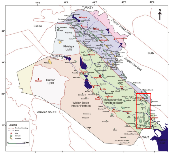
Zubair Formation was deposited during the Early Cretaceous epoch at the Barremain age within the Mesopotamian basin. This study is including lithofacies analysis of the Zubair succession in four wells XXX-1, X-1 and XX-5 within XXX, X and XX oil fields. The area under study is located in the south of Iraq in the Mesopotamian zone. The XXX oil field covers an area of 340 km
2 and is located 65 km south of Basra in southern Iraq. X oil field is located 15 km to the northeast of Amara City in Misan Governorate. The field is representing a NW-SE trending anticline, and is about 20 km long and 6.5 km wide. While XX oil field is located in the South of Iraq in XX oilfield. XX oil field is located in Southern Iraq approximately 60 Km. Northwestern of Basra city, close to the Iranian border and extending North to Missan province (
Figure 1).
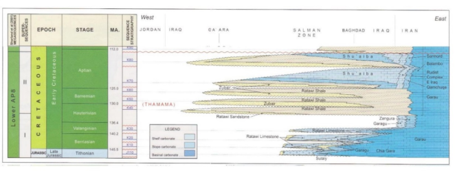
The Zubair Formation represents a Barremain sequence which belong to the Late Tithonian-Early Turonian Megasequence. This succession was deposited within a large intra shelf basin during a new tectonic phase of sea-floor spreading in the southern part of Neo Tethys. Differential tectonic subduction and the resulting changes in thickness that occur along transverse faults. The axis of this sediment basin has been moved to the east of the Mesopotamian zone towards the Tigris basin from its previous location in the Salman and Western Mesopotamian zones
| [6] | Jassim S. Z. and Goff J. C. 2006. Geology of Iraq. Dolin, Prague and Moravian Museum, Brno. pp: 341. |
[6]
.
Al-Zaidy A. A.
| [4] | Al-Zaidy A. A. 2020. Facies architecture and stratigraphic sequence of Zubair Formation in Majnoon and Suba oil fields, Southern Iraq. Modeling Earth Systems and Environment (2020) 6: 779–792. |
[4]
studied stratigraphic evolution of the Zubair sequence of XX and XXXX oil fields through lithofascic analysis. It proposed that the succession would be stored during the three deposition phases of the Transboundary Sea Level Stakes (TST), which ended with the appearance of a shale dominated unit in a well-ordered quartz-bearing lithofascia to indicate the maximum inundation area (mfs) of the XXXX oil field. Whereas in the XX oil field, the Zubair sequence is distinguished by three deposition cycles, represented by the sequence of the delta plain and the delta front, which are associated with shale-dominated units. In addition, it has been studied in the lithofascia and stratigraphy of the Zubair succession at the Kifl oil field
| [3] | Al-Zaidy A. A. 2019. Facies Analysis and Sequence Stratigraphy of the Zubair Formation in the Kifl oil field, Central of Iraq. Iraqi Journal of Science, 2019, Vol. 60, No. 2, pp: 341-352. |
[3]
.
Ali, R. H. and Al-Zaidy A. A. H.
| [2] | Ali, R. H. and Al-Zaidy A. A. H., 2020. Lithofacies Analysis and Depositional Development of Zubair Formation in West Qurna Oil Field, Southern Iraq. JOURNAL of UNIVERSITY of BABYLON for Pure and Applied Sciences, (JUBPAS). Vol. 28 No. 3(2020). |
[2]
studied the petrography, lithofacies analysis and depositional development for the Zubair Formation in XXX-1 in the XXX oil field.
Zubair and Ratawi successions are represented a clastic shelf which covered by the shallow marine carbonate of Shuaiba Formation following by prograding of the Zubair and Ratawi succession (
Figure 2).
| [6] | Jassim S. Z. and Goff J. C. 2006. Geology of Iraq. Dolin, Prague and Moravian Museum, Brno. pp: 341. |
[6]
were suggested that the Zubair basin depocenter was situated in the east of the Salman Zone
| [5] | Aqrawi, A. A. M., Goff, J. C., Horbury, A. D. and Sadooni, F. N., 2010. The petroleum Geology of Iraq. Scientific Press Ltd., 424 pp. |
[5]
, and the maximum values of thickness is appeared to the north of studied area.
The purpose of this study is to establish of depositional environment and the relationship of the lithofacies changings with the petrophysical characteristic of Zubair succession in the XXX, XX and X oil field in Southern of Iraq.
2. Methodology
The present study has been completed in three phases:
1) The field work which including collect the core and cutting samples and their description (
Table 1).
2) Laboratory work, samples were selected and thin sections prepared. Petrographic study and lithofascology analysis based on study of thin sections of cuttings and core from selected wells from the studied oil fields.
3) At this stage, the study and treatment of the available well logs were used to calculate the shale volume and porosity.
3. Facies Analysis of Zubair Formation
The interplay of tectonic development, sea level fluctuations, the rate of sediment supplementation, the physical and biological activity processes of sediment transportation and sedimentation, and climatic effects and changes determines the sedimentology and reservoir characteristics of clastic sedimentary rocks. The stratigraphic framework of the basin is the result of these processes interacting at the basin scale to produce the geometric distribution and arrangement of various depositional environments or stratigraphic tracts over time
| [6] | Jassim S. Z. and Goff J. C. 2006. Geology of Iraq. Dolin, Prague and Moravian Museum, Brno. pp: 341. |
[6]
.
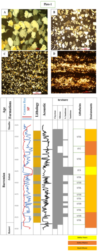
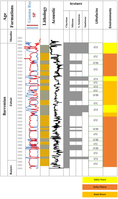
Thus, for three boreholes, the Zubair succession contains four lithofacies (
Figures 3, 4, and 5), which were explained using these parameters.
1) Sandstone Lithofacies I (Lf. S): - which characterized by fine-grained, well-sorted sandstone with a mode of subangular to subrounded grains (Plt. 1A) are lithofacies. This lithofacies' sandstone is classified as quartz arenite sandstone because it contains more than 90% quartz. This manifests as extremely low gamma ray values and negative SP values with box-shaped mode in the middle of XX-5 and X-1 and throughout XXX-1. of log response (GR and SP).
2) Silty Sandstone Lithofacies II (Lf. SS): - this lithofacies is characterized by a wide range of sand grain size from medium to coarse sand size (poorly sorted), and well-rounded to subrounded grain shape mode (Plt.1B). Approximately 90% of the sandstone in lithofacies silty sandstone is quartz, which is classified as quartz arenite and was found in the upper unit of the Zubair Formation. This lithofacies, which show upward finning with a bell-shaped gamma ray log mode and negative SP log values, are found throughout the entire Zubair succession in the wells under study.
3) Lithofacies of Siltstone (Lf. SL): These lithofacies, which are characterized by a high volume of shale with a funnel-shaped mode, appeared in the sandstone members as shale lenses. This facies' primary constituents are mud-dominated rocks with quartz minerals, which have angular grain shapes (Plt. 1C).
4) Clayey Lithfacies (Lf.C): - This lithofascism occurs in all parts of the Zubair-family. which consist of clay-dominated rocks (Pt.1D), with high gamma-ray values in the bell-shaped form.
Figure 3. Column (X-1) shows the distribution of lithofacies and the main depositional environment.
A. Sandstone Lithofacies, XX-1 depth 3277.37-78.37m
B. Silty sandstone Lithofacies, XXX-2 depth 3238m
C. Siltstone Lithofacies, XXX-2 depth 3232m
D. Clayey Lithofacies, X-1 depth 4410m
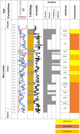
Figure 4. The distribution of lithofacies and the main depositional environments are displayed in the columnar section (XX-5).
Figure 5. The distribution of lithofacies and the main depositional environments are displayed in the columnar section (XXX-2).
4. Zubair Rock Units
The X succession thickness values in the studied area are varying from 310m to 358m (
Table 1).
The succession under study is divided into three main units using well logging tools (GR, SP, and DT) (
Figure 6). The upper member is primarily made up of sand layers with thin shale beds, the middle member is made up of thin layers of sandstone with a predominance of shale, and the lower member is primarily made up of shale with less sandstone.
4.1. Lower Unit
In every well under study, the lower unit of this succession is characterized by a shale-dominated unit with high gamma ray log values and numerous cycles that flow upward (bell-shaped). In the area under study, the lower unit is separated into five shale/sandstone cycles, with the sandstone beds being thinned upward. The thickness of this unit is ranging from 100 m in X-1 to 135 m in XXX-2 with dominance of delta Plaine association in XXX-2 and XX-5, while in X-1 was the back shore association.
4.2. Middle Unit
This unit is the smallest in the succession under study. It is dominated by sandstone, with thicknesses ranging from 25 m in X-1 to 90 m in XX-5 and 120 m in XXX-2. Two patterns of variation emerged in the lateral distribution of this unit. The first pattern is found in the northern portion of the studied area (X-1), where one cycle of sandstone appears as an aggrading box car pattern (cylinder shape). The second pattern, which is characterized by fining upward of sandstone-dominated succession with a funnel-shaped log response, was identified in the southern portion of the studied area (XX-5 and XXX-2). In XX-5 and XXX-2, this unit was deposited within a sequential delta front and back shore association facies; in No-1, it was deposited within a thinner delta front.
4.3. Upper Unit
The upper unit shows high shale values, indicating a succession dominated by shale, and the overall gamma ray log trend is nearly identical to bell and box car patterns, indicating a comparatively declining upward trend in gamma ray values in all examined wells with the exception of the X-1 is showing the most clay content with three cycle of shale dominated succession as funnel shape, with thickness ranging from 80 m in X-1 and XX-5 to 100 m in XXX-2. This unit was deposited in deposition cycle with delta plain and back shore association facies in the northern part of the studied area (X-1), while to the south was the deposition in the sequential of delta front and delta plain.
5. Petrophysical Property Model
The petrographic observations which described above are in terms of the fabric if rock units and petrophysical zones. The petrophysical parameters and horizons of these unit rocks can be converted into reservoir property models most effectively We have an interpretation and description of the log's porosity and porosity assessment based on the three units (upper unit, middle unit, and lower unit) into which the Zubair succession can be divided based on the gamma ray values and the volume of shale. The porosity log such as acoustic log in the studied boreholes showing an approximately matching with these unit in this succession.
Instead of using logs that read the depth formation, the interactive petrophysical software plots the porosity to depth relationship for each borehole under study. In order to identify the zones of void space as primary and initial porosity that are connected and therefore capable of transmitting fluids through the rock unit (effective porosity), the initial porosity from the sonic well log is examined.
Based on total and active porosity, these petrophysical zones can be classified into three different types of rock units as high to moderate values of active porosity rocks (type I), rocks with moderate levels of active porosity (type II), and low to non-porous rock unit (type III).
5.1. Lower Zone
The lower zone of Zubair succession is represented by the shale – dominated rocks, with low to non-pores rock unit (type III). There are limit presences of the high to moderate values of active porosity type (I) of the rock unit within the shale bands lithofacies which appears in studied wells.
5.2. Middle Zone
This zone is represented by two subzones in studied succession. Because of the high shale content, the lower subzone of this zone is characterized by low to non-pores rock unit (type III) and moderate values of active porosity (type II), whereas the upper subzone is characterized by high to moderate values of active porosity (type I). This zone is represented the middle part of the Zubair succession within the shale dominated members.
5.3. Upper Zone
Due to the well-sorted coarse grain sandstone, this zone is represented by high to moderate values of active porosity petrophysics zone (type I). These characteristics are consistent with low to moderate shale values and shale-dominated rock units.
6. Computer Processing Interpretation
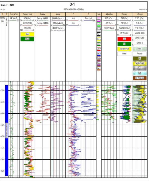
6.1. Computer Processing Interpretation of Well X-1
Figure 6. Computer Processing Interpretation (CPI) of the Zubair Formation at well X-1.
The well's results indicated that there is only one primary reservoir unit. This unit starts in the middle zone at a depth of 4400–4450 m and is distinguished by a high resistivity value and a low gamma ray value. High effective porosity and a high potential for hydrocarbon saturation are characteristics of this unit (
Figure 6).
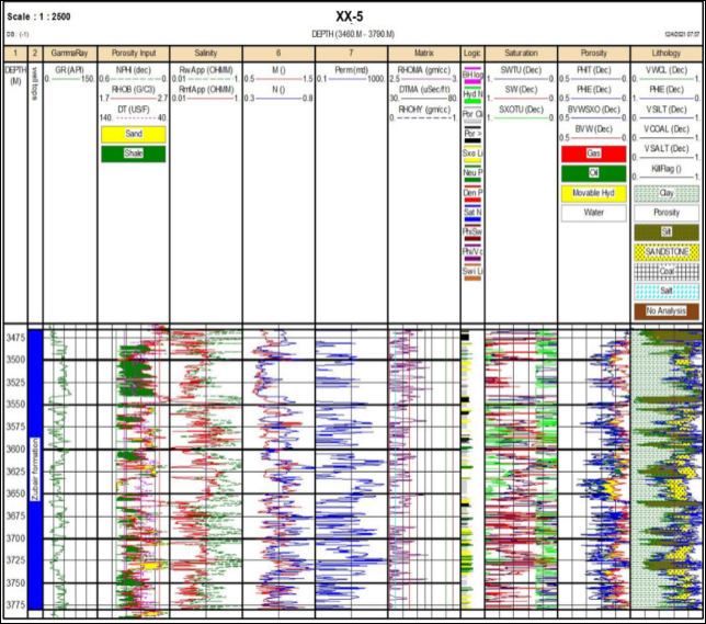
6.2. Computer Processing Interpretation of Well XX-5
Two primary reservoir units comprise the Zubair Formation in Well XX-5. High resistivity and low gamma-ray values define the first unit. High hydrocarbon saturation is followed by high effective porosity. This unit is located in the middle zone at a depth of 3530–4600 meters. Low gamma-ray values and high to moderate resistivity values define the second unit. There was a moderate level of hydrocarbon saturation and porosity. This unit's depth in the upper zone is between 3465 and 3485 meters (
Figure 7).
Figure 7. Computer Processing Interpretation (CPI) of the Zubair Formation at well XX-5.
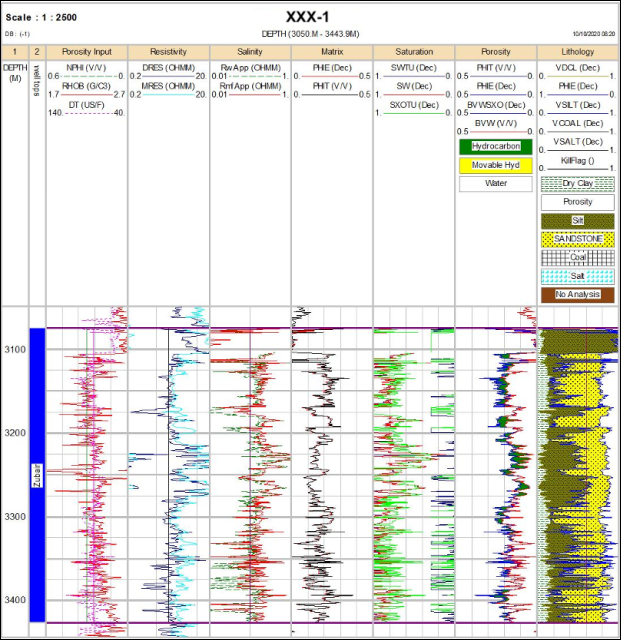
6.3. Computer Processing Interpretation of Well XXX-2
There are two main reservoir units in the XXX-2. The first reservoir unit has low Gamma-ray values and moderate resistivity. With a moderate hydrocarbon saturation, the effective porosity values are moderate. This unit is between 3180 and 3280 meters deep. The second reservoir unit, on the other hand, has high to moderate effective porosity, high to moderate hydrocarbon saturation, and high to moderate resistivity values with low gamma-ray values. The depth of 3075–3100 meters (
Figure 8).
Figure 8. Computer Processing Interpretation (CPI) of the Zubair Formation at well XXX-1.
7. Conclusions
Associated facies and depositional settings. Delta Front Association Facies, Back Shore Association Facies, and Delta Plain Association Facies are the three primary associations of deltaic facies in succession studies, which are interpreted based on the available parameters and distribution of the observable lithofacies. Three major units are characterized the studied succession which divided by using well logging tools (GR, SP and DT). The lower member consists mainly of shale with less sandstone; the middle member is consisting of thin layers of sandstone with dominance of shale, and sand layers with thin shale beds make up the majority of the upper member: - Lower unit shale dominated, Middle unit sandstone dominated and upper unit sand/shale dominated.
There are three different kinds of petrophysics property features in the Zubair succession based on the relationship between resistivity, porosity, and gamma rays.
1) High values of gamma ray- Low resistivity values
2) High gamma ray values - High resistivity values
3) Low values of gamma ray- High resistivity values
4) Low gamma ray values - Low resistivity values
At the XXX oil field, the upper unit rock of the Zubair succession is divided into two zones. The upper portion of this unit is represented by the first zone, which displays high resistivity and gamma rays, while the lower zone displays low resistivity and gamma rays. Within the upper zone, there are numerous subhorizons as bands with low gamma rays and high resistivity. The XXX oil field was divided into three zones. High resistivity and high gamma ray values are displayed in the first, high resistivity and low gamma ray values are displayed in the second, and a combination of high resistivity and high gamma ray values with low resistivity and low gamma ray values characterizes the final unit. Two excellent reservoir zones with low water saturation and high oil saturation exist.
Abbreviations
GR | Gamma-Ray Log |
SP | Spontaneous Potential Log |
DT | Sonic Log |
TST | Transgressive Systems Tract |
MFS | Maximum Flooding Surface |
Pt | Plate |
CPI | Computer Processing Interpretation |
Acknowledgments
The authors are grateful to the Oil Exploration Company (Ministry of Oil) for providing the data for this study.
Author Contributions
Haider Ahmed Falih Al-Tarim: Conceptualization, Methodology, Supervision, Funding acquisition, Writing original draft, Data curation, Formal Analysis, Software, Validation, Visualization, Investigation, Resources
Zainab Ali Shakir Al-Khalidi: Project administration, Writing – review & editing
Conflicts of Interest
The authors declare no conflicts of interest and This research received no external funding.
References
| [1] |
Al-Ameri T. K., Al-Ahmed A., Zumberge J., Pitman J. K., 2010. Hydrocarbon potential of the Middle Jurassic Sargelu Formation, Zagros Fold Belt, northern Iraq”. AAPG Search and Discovery Article, no. 90090, Annual Convention and Exhibition, Denver, Colorado.
|
| [2] |
Ali, R. H. and Al-Zaidy A. A. H., 2020. Lithofacies Analysis and Depositional Development of Zubair Formation in West Qurna Oil Field, Southern Iraq. JOURNAL of UNIVERSITY of BABYLON for Pure and Applied Sciences, (JUBPAS). Vol. 28 No. 3(2020).
|
| [3] |
Al-Zaidy A. A. 2019. Facies Analysis and Sequence Stratigraphy of the Zubair Formation in the Kifl oil field, Central of Iraq. Iraqi Journal of Science, 2019, Vol. 60, No. 2, pp: 341-352.
|
| [4] |
Al-Zaidy A. A. 2020. Facies architecture and stratigraphic sequence of Zubair Formation in Majnoon and Suba oil fields, Southern Iraq. Modeling Earth Systems and Environment (2020) 6: 779–792.
|
| [5] |
Aqrawi, A. A. M., Goff, J. C., Horbury, A. D. and Sadooni, F. N., 2010. The petroleum Geology of Iraq. Scientific Press Ltd., 424 pp.
|
| [6] |
Jassim S. Z. and Goff J. C. 2006. Geology of Iraq. Dolin, Prague and Moravian Museum, Brno. pp: 341.
|
Cite This Article
-
APA Style
Al-Tarim, H. A. F., Al-Khalidi, Z. A. S. (2026). Lithofacies Analysis and Petrophysical Relationships of Zubair Formation in X, XX and XXX Oil Fields, Southern Iraq. American Journal of Physics and Applications, 14(3), 40-49. https://doi.org/10.11648/j.ajpa.20261403.12
 Copy
|
Copy
|
 Download
ACS Style
Al-Tarim, H. A. F.; Al-Khalidi, Z. A. S. Lithofacies Analysis and Petrophysical Relationships of Zubair Formation in X, XX and XXX Oil Fields, Southern Iraq. Am. J. Phys. Appl. 2026, 14(3), 40-49. doi: 10.11648/j.ajpa.20261403.12
Copy
|
Download
AMA Style
Al-Tarim HAF, Al-Khalidi ZAS. Lithofacies Analysis and Petrophysical Relationships of Zubair Formation in X, XX and XXX Oil Fields, Southern Iraq. Am J Phys Appl. 2026;14(3):40-49. doi: 10.11648/j.ajpa.20261403.12
Copy
|
Download
-
@article{10.11648/j.ajpa.20261403.12,
  author = {Haider Ahmed Falih Al-Tarim and Zainab Ali Shakir Al-Khalidi},
  title = {Lithofacies Analysis and Petrophysical Relationships of Zubair Formation in X, XX and XXX Oil Fields, Southern Iraq},
  journal = {American Journal of Physics and Applications},
  volume = {14},
  number = {3},
  pages = {40-49},
  doi = {10.11648/j.ajpa.20261403.12},
  url = {https://doi.org/10.11648/j.ajpa.20261403.12},
  eprint = {https://article.sciencepublishinggroup.com/pdf/10.11648.j.ajpa.20261403.12},
  abstract = {The current study is including the lithofacies analysis and petrophysical evaluation related to depositional development for Zubair Formation in X, XX and XXX oil fields (X-1, XX-5 and XXX-2). Zubair Formations was deposited in the Mesopotamian Zone during the Barremain age which belong to the Early Cretaceous epoch. Depositional settings and related facies that were interpreted using the supplied parameters and distribution of the observable lithofacies, there are three main associations of deltaic facies in studies succession: - Delta Front Association Facies, Back Shore Association Facies, Delta Plain Association Facie. The succession under study is separated into three main units utilizing well logging technologies (GR, SP, and DT). The upper part is primarily made up of sand layers with thin shale beds, the middle member is made up of thin layers of sandstone with a predominance of shale, and the lower member is primarily built of shale with less sandstone: - Lower unit shale dominated, Middle unit sandstone dominated and upper unit sand/shale dominated. The lower petrophysical zone of Zubair succession is represented by the shale dominated rock units, with low to non-pores rock unit (type III). Active porosity type (I) is present in low to moderate levels within the shale bands lithofacies across all examined wells. The middle zone in the studied succession is split into two subzones. The upper subzone exhibits high to moderate levels of active porosity (type I), whereas the lower subzone shows moderate levels of active porosity (type II) and a low to non-porous rock unit (type III) due to a significant amount of shale content. This zone represents the middle section of the Zubair succession within the shale-dominated layers. The upper zone consists of high to medium-sized active porosity rocks (Type I) due to well-graded coarse granitic sandstones. These features correspond to shale-dominated rocks and low to medium shale grades.},
 year = {2026}
}
Copy
|
Download
-
TY  - JOUR
T1  - Lithofacies Analysis and Petrophysical Relationships of Zubair Formation in X, XX and XXX Oil Fields, Southern Iraq
AU  - Haider Ahmed Falih Al-Tarim
AU  - Zainab Ali Shakir Al-Khalidi
Y1  - 2026/06/12
PY  - 2026
N1  - https://doi.org/10.11648/j.ajpa.20261403.12
DO  - 10.11648/j.ajpa.20261403.12
T2  - American Journal of Physics and Applications
JF  - American Journal of Physics and Applications
JO  - American Journal of Physics and Applications
SP  - 40
EP  - 49
PB  - Science Publishing Group
SN  - 2330-4308
UR  - https://doi.org/10.11648/j.ajpa.20261403.12
AB  - The current study is including the lithofacies analysis and petrophysical evaluation related to depositional development for Zubair Formation in X, XX and XXX oil fields (X-1, XX-5 and XXX-2). Zubair Formations was deposited in the Mesopotamian Zone during the Barremain age which belong to the Early Cretaceous epoch. Depositional settings and related facies that were interpreted using the supplied parameters and distribution of the observable lithofacies, there are three main associations of deltaic facies in studies succession: - Delta Front Association Facies, Back Shore Association Facies, Delta Plain Association Facie. The succession under study is separated into three main units utilizing well logging technologies (GR, SP, and DT). The upper part is primarily made up of sand layers with thin shale beds, the middle member is made up of thin layers of sandstone with a predominance of shale, and the lower member is primarily built of shale with less sandstone: - Lower unit shale dominated, Middle unit sandstone dominated and upper unit sand/shale dominated. The lower petrophysical zone of Zubair succession is represented by the shale dominated rock units, with low to non-pores rock unit (type III). Active porosity type (I) is present in low to moderate levels within the shale bands lithofacies across all examined wells. The middle zone in the studied succession is split into two subzones. The upper subzone exhibits high to moderate levels of active porosity (type I), whereas the lower subzone shows moderate levels of active porosity (type II) and a low to non-porous rock unit (type III) due to a significant amount of shale content. This zone represents the middle section of the Zubair succession within the shale-dominated layers. The upper zone consists of high to medium-sized active porosity rocks (Type I) due to well-graded coarse granitic sandstones. These features correspond to shale-dominated rocks and low to medium shale grades.
VL  - 14
IS  - 3
ER  -
Copy
|
Download