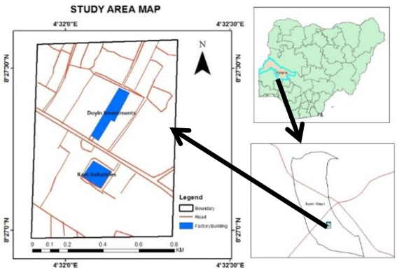
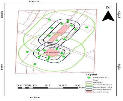
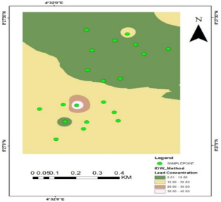
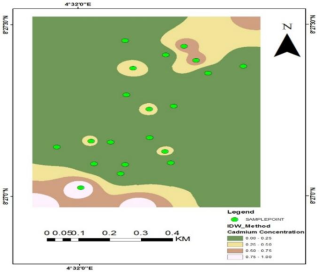
Industrial activities are among the major sources of heavy metal accumulation in soils, posing significant threats to environmental quality, ecosystem stability, and public health due to the persistence and bioaccumulative nature of toxic metals. Among these pollutants, lead (Pb) and cadmium (Cd) are widely recognized as critical indicators of industrial contamination because of their potential mobility through soil–water–plant systems and subsequent entry into the food chain. In response to increasing industrialization around the Asa Dam area in Ilorin, Kwara State, Nigeria, this study evaluated the spatial distribution and concentration of Pb and Cd in soils within selected industrial zones. A total of ten soil samples were systematically collected from each industrial site at a depth of 20 cm during the wet season, and sampling locations were georeferenced using a Garmin Global Positioning System (GPS) receiver. The concentrations of Pb and Cd were determined using Atomic Absorption Spectrophotometry (AAS), while spatial distribution patterns were analyzed and mapped using the Inverse Distance Weighting (IDW) interpolation technique within a Geographic Information System (GIS) environment. The results showed that the concentrations of Pb and Cd across all sampled locations remained below the permissible limits recommended by the World Health Organization (WHO). Comparatively higher concentrations were observed around KAM Industries relative to Doyin Investments, although these values were still within acceptable environmental thresholds. The spatial distribution maps further indicated localized variations in heavy metal concentrations without evidence of severe contamination hotspots. Overall, the findings suggest that soils within the Asa Dam industrial corridor are presently not significantly contaminated by Pb and Cd and therefore pose minimal immediate ecological and human health risks. Nevertheless, continuous environmental monitoring is recommended to ensure early detection of potential future contamination associated with ongoing industrial expansion in the area.
| Published in | American Journal of Environmental Science and Engineering (Volume 10, Issue 2) |
| DOI | 10.11648/j.ajese.20261002.13 |
| Page(s) | 63-73 |
| Creative Commons |
This is an Open Access article, distributed under the terms of the Creative Commons Attribution 4.0 International License (http://creativecommons.org/licenses/by/4.0/), which permits unrestricted use, distribution and reproduction in any medium or format, provided the original work is properly cited. |
| Copyright |
Copyright © The Author(s), 2026. Published by Science Publishing Group |
Industrial Area, Heavy Metal, Environmental, Lead (Pb), Cadmium (Cd), Pollution, Random Sample
S/N | Sample Code | Lead (Pb) (mg/kg) | Cadmium (Cd) (mg/kg) |
|---|---|---|---|
1 | D1 | 13.33 | 0.67 |
2 | D2 | 6.67 | 0 |
3 | D3 | 6.67 | 0 |
4 | D4 | 10 | 0.33 |
5 | D5 | 3.33 | 0 |
6 | D6 | 0 | 0.67 |
7 | D7 | 10 | 0.33 |
8 | D8 | 3.33 | 0 |
9 | D9 | 6.67 | 0 |
10 | D10 | 10 | 0 |
S/N | Sample Code | Lead (Pb) (mg/kg) | Cadmium (Cd) (mg/kg) |
|---|---|---|---|
1 | K1 | 6.67 | 0 |
2 | K2 | 13.33 | 0 |
3 | K3 | 10 | 0.33 |
4 | K4 | 13.33 | 0 |
5 | K5 | 10 | 0 |
6 | K6 | 13.33 | 0.33 |
7 | K7 | 40 | 0 |
8 | K8 | 13.33 | 0 |
9 | K9 | 16.67 | 0 |
10 | K10 | 13.33 | 1 |
S/N | Parameters | Denmark Standards | WHO Standards | NESREA Standards |
|---|---|---|---|---|
1 | Cadmium | 5 | 10 | 3 – 6 |
2 | Chromium | Not fixed | Not fixed | Not fixed |
3 | Lead | 40 | 70 | 250 – 500 |
4 | Iron | Not fixed | Not fixed | Not fixed |
5 | Zinc | 500 | 200 | 300 – 600 |
AAS | Atomic Absorption Spectrophotometry |
BRC | British Reinforcement Concrete |
Cd | Cadmium |
Cr | Chromium |
Cu | Copper |
Fe | Iron |
GPS | Global Positioning System |
IDW | Inverse Distance Weighting |
Mn | Manganese |
Pb | Lead |
WHO | World Health Organization |
Zn | Zinc |
| [1] | M. Chino, T. B. Goh, P. H. Hsu, D. W. Oscarson, and L. M. Shuman, Soils and Groundwater Pollution and Remediation. CRC Press, 2020. |
| [2] | G. Idowu, “Heavy Metals Research in Nigeria: A Review of Studies and Prioritization of Research needs,” Apr. 13, 2022. |
| [3] | J. O. Nriagu, “A History of Global Metal Pollution,” Science (1979)., vol. 272, no. 5259, pp. 223–223, Apr. 1996, |
| [4] | C. O. Ogunkunle, K. Mustapha, S. Oyedeji, and P. O. Fatoba, “Assessment of metallic pollution status of surface water and aquatic macrophytes of earthen dams in Ilorin, north-central of Nigeria as indicators of environmental health,” J. King Saud Univ. Sci., vol. 28, no. 4, pp. 324–331, Oct. 2016, |
| [5] | F. A. Adekola and O. A. A. Eletta, “A study of heavy metal pollution of Asa River, Ilorin. nigeria; trace metal monitoring and geochemistry,” Environ. Monit. Assess., vol. 125, no. 1–3, pp. 157–163, Feb. 2007, |
| [6] | O. M. Kolawole, K. T. Ajayi, A. B. Olayemi, and A. I. Okoh, “Assessment of Water Quality in Asa River (Nigeria) and Its Indigenous Clarias gariepinus Fish,” Int. J. Environ. Res. Public Health, vol. 8, no. 11, pp. 4332–4352, Nov. 2011, |
| [7] | A. S. Adekunle, “Removal of heavy metals from industrial effluents by water hyacinth (Eichornia crassipes),” Journal of Environmental Chemistry and Ecotoxicology, vol. 4, no. 11, Sep. 2012, |
| [8] | A. van Geen, C. Bravo, V. Gil, S. Sherpa, and D. Jack, “Lead exposure from soil in Peruvian mining towns: a national assessment supported by two contrasting examples,” Bull. World Health Organ., vol. 90, no. 12, pp. 878–886, Dec. 2012, |
| [9] | M. F. Goodchild, L. T. Steyaert, B. O. Parks, C. Johnston, D. Maidment, M. Crane, and S. Glendinning, GIS and Environmental Modeling: Progress and Research Issues. Washington, DC, USA: GIS World Books, 1993. |
| [10] | C. Zhang and O. Selinus, “Statistics and GIS in environmental geochemistry — some problems and solutions,” J. Geochem. Explor., vol. 64, no. 1–3, pp. 339–354, Nov. 1998, |
| [11] | H. O. SAWYERR, M. O. RAIMI, A. T. ADEOLU, and O. E. ODIPE, “Measures of Harm from Heavy Metal Pollution in Battery Technicians’ Workshop within Ilorin Metropolis, Kwara State, Nigeria,” Communication, Society and Media, vol. 2, no. 2, p. 73, May 2019, |
| [12] | C. I. C. Ebirim, A. N. Amadi, O. C. Abanobi, and G. U. P. Iloh, “The Prevalence of Cigarette Smoking and Knowledge of Its Health Implications among Adolescents in Owerri, South-Eastern Nigeria,” Health N. Hav., vol. 06, no. 12, pp. 1532–1538, 2014, |
| [13] | L. H. J. Lajunen and P. Peramaki, Spectrochemical Analysis by Atomic Absorption and Emission. The Royal Society of Chemistry, 2004. |
| [14] | P. A. Burrough, Rachael A. McDonnell, and Christopher D. Lloyd, Principles of Geographical Information Systems. New York.: Oxford University Press, 2000. |
| [15] | O. Huisman and R. A. de By, Principles of geographic information systems: an introductory textbook, vol. 1. International Institute for Geo-Information Science and Earth Observation.: ITC Educational Textbook Series: ITC, 2009. |
| [16] | L. Simon, “Potentially Harmful Elements in Agricultural Soils,” in PHEs, Environment and Human Health, Dordrecht: Springer Netherlands, 2014, pp. 85–150. |
| [17] | B. J. Alloway, Ed., Heavy Metals in Soils, vol. 22. Dordrecht: Springer Netherlands, 2013. |
| [18] | J. O. Nriagu and J. M. Pacyna, “Quantitative assessment of worldwide contamination of air, water and soils by trace metals,” Nature, vol. 333, no. 6169, pp. 134–139, May 1988, |
| [19] | A. Kabata-Pendias, Trace Elements in Soils and Plants. CRC Press, 2010. |
| [20] | L. Järup, “Hazards of heavy metal contamination,” Br. Med. Bull., vol. 68, no. 1, pp. 167–182, Dec. 2003, |
| [21] | J. C. Fussell et al., “A Review of Road Traffic-Derived Non-Exhaust Particles: Emissions, Physicochemical Characteristics, Health Risks, and Mitigation Measures,” Environ. Sci. Technol., vol. 56, no. 11, pp. 6813–6835, Jun. 2022, |
| [22] | M. A. Khan, I. Ahmad, and I. U. Rahman, “Effect of Environmental Pollution on Heavy Metals Content of Withania Somnifera,” Journal of the Chinese Chemical Society, vol. 54, no. 2, pp. 339–343, Apr. 2007, |
| [23] | C. M. A. Iwegbue, G. E. Nwajei, J. E. Ogala, and C. L. Overah, “Determination of trace metal concentrations in soil profiles of municipal waste dumps in Nigeria,” Environ. Geochem. Health, vol. 32, no. 5, pp. 415–430, Oct. 2010, |
| [24] | Water Quality Index Technical Subcommittee, “Canadian Water Quality Guidelines for the Protection of Aquatic Life,” 2001. |
| [25] | N. W. Davies, “Gas chromatographic retention indices of monoterpenes and sesquiterpenes on methyl silicon and Carbowax 20M phases,” J. Chromatogr. A, vol. 503, pp. 1–24, Jan. 1990, |
| [26] | M. B. McBride, “Toxic Metal Accumulation from Agricultural Use of Sludge: Are USEPA Regulations Protective?” J. Environ. Qual., vol. 24, no. 1, pp. 5–18, Jan. 1995, |
| [27] | G. F. El-Said and D. H. Youssef, “Ecotoxicological impact assessment of some heavy metals and their distribution in some fractions of mangrove sediments from Red Sea, Egypt,” Environ. Monit. Assess., vol. 185, no. 1, pp. 393–404, Jan. 2013, |
| [28] | W. Schröder, “GIS, geostatistics, metadata banking, and tree-based models for data analysis and mapping in environmental monitoring and epidemiology,” International Journal of Medical Microbiology, vol. 296, pp. 23–36, May 2006, |
| [29] | J. A. Carrero et al., “Diagnosing the Impact of Traffic on Roadside Soils Through Chemometric Analysis on the Concentrations of More Than 60 Metals Measured by ICP/MS,” 2009, pp. 329–336. |
| [30] | A. Rashid et al., “Heavy Metal Contamination in Agricultural Soil: Environmental Pollutants Affecting Crop Health,” Agronomy, vol. 13, no. 6, p. 1521, May 2023, |
| [31] | I. Sánchez-Castro, L. Molina, M.-Á. Prieto-Fernández, and A. Segura, “Past, present and future trends in the remediation of heavy-metal contaminated soil - Remediation techniques applied in real soil-contamination events,” Heliyon, vol. 9, no. 6, p. e16692, Jun. 2023, |
| [32] | H. Soleimani et al., “Ecological risk assessment and heavy metals accumulation in agriculture soils irrigated with treated wastewater effluent, river water, and well water combined with chemical fertilizers,” Heliyon, vol. 9, no. 3, p. e14580, Mar. 2023, |
APA Style
Alage, I. L., Ekpo, E. O., Olatoyinbo, S. F., Gbenga, O. A. (2026). GIS-Based Assessment of Soil Heavy Metal Contamination in Asa Dam Industrial Area Ilorin, Nigeria. American Journal of Environmental Science and Engineering, 10(2), 63-73. https://doi.org/10.11648/j.ajese.20261002.13
ACS Style
Alage, I. L.; Ekpo, E. O.; Olatoyinbo, S. F.; Gbenga, O. A. GIS-Based Assessment of Soil Heavy Metal Contamination in Asa Dam Industrial Area Ilorin, Nigeria. Am. J. Environ. Sci. Eng. 2026, 10(2), 63-73. doi: 10.11648/j.ajese.20261002.13
@article{10.11648/j.ajese.20261002.13,
  author = {Isiaka Lukman Alage and Ebeiyamba Okon Ekpo and Seyi Festus Olatoyinbo and Ojo Adebayo Gbenga},
  title = {GIS-Based Assessment of Soil Heavy Metal Contamination in Asa Dam Industrial Area Ilorin, Nigeria},
  journal = {American Journal of Environmental Science and Engineering},
  volume = {10},
  number = {2},
  pages = {63-73},
  doi = {10.11648/j.ajese.20261002.13},
  url = {https://doi.org/10.11648/j.ajese.20261002.13},
  eprint = {https://article.sciencepublishinggroup.com/pdf/10.11648.j.ajese.20261002.13},
  abstract = {Industrial activities are among the major sources of heavy metal accumulation in soils, posing significant threats to environmental quality, ecosystem stability, and public health due to the persistence and bioaccumulative nature of toxic metals. Among these pollutants, lead (Pb) and cadmium (Cd) are widely recognized as critical indicators of industrial contamination because of their potential mobility through soil–water–plant systems and subsequent entry into the food chain. In response to increasing industrialization around the Asa Dam area in Ilorin, Kwara State, Nigeria, this study evaluated the spatial distribution and concentration of Pb and Cd in soils within selected industrial zones. A total of ten soil samples were systematically collected from each industrial site at a depth of 20 cm during the wet season, and sampling locations were georeferenced using a Garmin Global Positioning System (GPS) receiver. The concentrations of Pb and Cd were determined using Atomic Absorption Spectrophotometry (AAS), while spatial distribution patterns were analyzed and mapped using the Inverse Distance Weighting (IDW) interpolation technique within a Geographic Information System (GIS) environment. The results showed that the concentrations of Pb and Cd across all sampled locations remained below the permissible limits recommended by the World Health Organization (WHO). Comparatively higher concentrations were observed around KAM Industries relative to Doyin Investments, although these values were still within acceptable environmental thresholds. The spatial distribution maps further indicated localized variations in heavy metal concentrations without evidence of severe contamination hotspots. Overall, the findings suggest that soils within the Asa Dam industrial corridor are presently not significantly contaminated by Pb and Cd and therefore pose minimal immediate ecological and human health risks. Nevertheless, continuous environmental monitoring is recommended to ensure early detection of potential future contamination associated with ongoing industrial expansion in the area.},
 year = {2026}
}
TY  - JOUR
T1  - GIS-Based Assessment of Soil Heavy Metal Contamination in Asa Dam Industrial Area Ilorin, Nigeria
AU  - Isiaka Lukman Alage
AU  - Ebeiyamba Okon Ekpo
AU  - Seyi Festus Olatoyinbo
AU  - Ojo Adebayo Gbenga
Y1  - 2026/06/15
PY  - 2026
N1  - https://doi.org/10.11648/j.ajese.20261002.13
DO  - 10.11648/j.ajese.20261002.13
T2  - American Journal of Environmental Science and Engineering
JF  - American Journal of Environmental Science and Engineering
JO  - American Journal of Environmental Science and Engineering
SP  - 63
EP  - 73
PB  - Science Publishing Group
SN  - 2578-7993
UR  - https://doi.org/10.11648/j.ajese.20261002.13
AB  - Industrial activities are among the major sources of heavy metal accumulation in soils, posing significant threats to environmental quality, ecosystem stability, and public health due to the persistence and bioaccumulative nature of toxic metals. Among these pollutants, lead (Pb) and cadmium (Cd) are widely recognized as critical indicators of industrial contamination because of their potential mobility through soil–water–plant systems and subsequent entry into the food chain. In response to increasing industrialization around the Asa Dam area in Ilorin, Kwara State, Nigeria, this study evaluated the spatial distribution and concentration of Pb and Cd in soils within selected industrial zones. A total of ten soil samples were systematically collected from each industrial site at a depth of 20 cm during the wet season, and sampling locations were georeferenced using a Garmin Global Positioning System (GPS) receiver. The concentrations of Pb and Cd were determined using Atomic Absorption Spectrophotometry (AAS), while spatial distribution patterns were analyzed and mapped using the Inverse Distance Weighting (IDW) interpolation technique within a Geographic Information System (GIS) environment. The results showed that the concentrations of Pb and Cd across all sampled locations remained below the permissible limits recommended by the World Health Organization (WHO). Comparatively higher concentrations were observed around KAM Industries relative to Doyin Investments, although these values were still within acceptable environmental thresholds. The spatial distribution maps further indicated localized variations in heavy metal concentrations without evidence of severe contamination hotspots. Overall, the findings suggest that soils within the Asa Dam industrial corridor are presently not significantly contaminated by Pb and Cd and therefore pose minimal immediate ecological and human health risks. Nevertheless, continuous environmental monitoring is recommended to ensure early detection of potential future contamination associated with ongoing industrial expansion in the area.
VL  - 10
IS  - 2
ER  -
African Regional Centre for Space Science and Technology Education - English, Obafemi Awolowo University, Ile-Ife, Nigeria;National Space Research and Development Agency, Abuja, Nigeria
African Regional Centre for Space Science and Technology Education - English, Obafemi Awolowo University, Ile-Ife, Nigeria;National Space Research and Development Agency, Abuja, Nigeria
African Regional Centre for Space Science and Technology Education - English, Obafemi Awolowo University, Ile-Ife, Nigeria;National Space Research and Development Agency, Abuja, Nigeria
African Regional Centre for Space Science and Technology Education - English, Obafemi Awolowo University, Ile-Ife, Nigeria;National Space Research and Development Agency, Abuja, Nigeria
Information